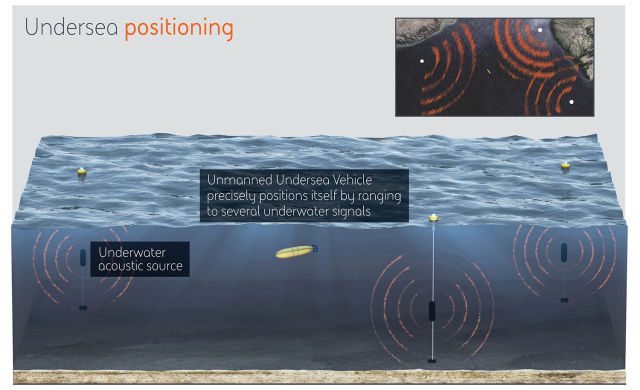
DARPA to Create an Undersea GPS System
Gareth Andrews / 8 years ago
We all get lost, it just happens. Over the years people have changed how they avoided this fact of life, some drew maps on paper while others have more recently started relying on satellites and global positioning systems (GPS) to tell them their exact location and even directions to where they want to go. The Defence Advanced Research Projects Agency (DARPA) looks to bring a similar technology to GPS to their underwater transportation, be it a drone or a submarine.
GPS works by carrying time and position data over radio waves, this gives your phone, satnav or computer the ability to calculate its position. The problem with this technique is when the radio waves hit the water, the signals can’t get very deep under water. A submarine typically would raise itself to the surface, using an antenna to calculate its location.
The new system, POSYDON (Positioning System for Deep Ocean Navigation) is being made by a group of universities within the US and BAE Systems. The end result was a set of devices which will use sound waves to inform vehicles of time and position data with any underwater vehicles using the pings from several underwater buoys to calculate their location just like any other GPS system.